Final photo from iconic US satellite shows how Las Vegas has ‘doubled’ in size over the last 25 years — Earth from space

QUICK FACTS
Where is it? Las Vegas, Nevada [36.10457930, -115.1448612]
What’s in the photos? Aerial shots taken at the start and end of a satellite’s operational lifespan
Which satellite took the photos? Landsat 7
When were the photos taken? July 4, 1999 and May 28, 2024
The last image captured by the recently decommissioned Landsat 7 satellite shows the sprawling mass of Las Vegas flowering in the heart of the Mojave Desert. The final photo also mirrors one of the satellite’s first-ever shots, highlighting how “Sin City” has rapidly expanded during the iconic spacecraft’s 25-year lifespan.
Landsat 7 is an Earth-observing satellite co-owned by NASA and the U.S. Geological Survey (USGS) that orbits our planet roughly every 99 minutes. It was launched on April 15, 1999, and has since taken more than 3.3 million images of Earth’s surface, covering almost every square inch of the globe.
On June 4, the satellite received its final transmission from operators, marking the official end of its mission after a year-long decommissioning process that took the spacecraft out of the path of other satellites before it ran out of fuel. Landsat 7 will now drift in space for around 55 years before eventually reentering and burning up in the atmosphere, according to a USGS statement.
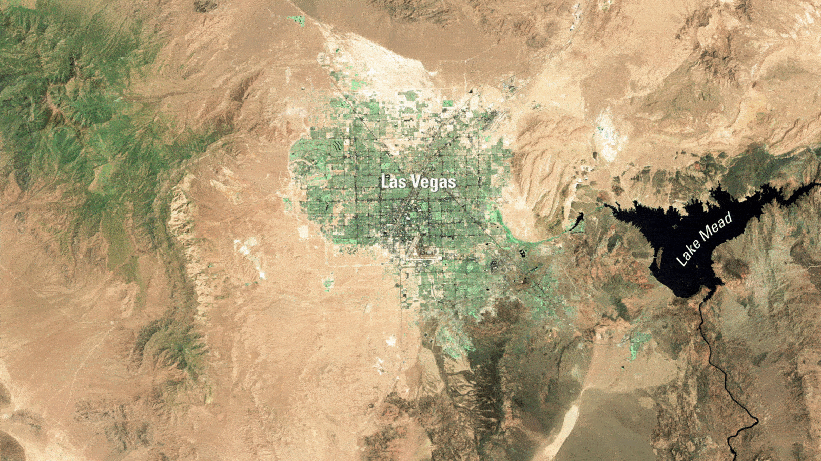
The satellite’s final image was captured on May 28, 2024. It shows the Las Vegas metropolitan area, including towns such as Henderson, Paradise and Spring Valley, sprawled across the Nevada desert.
The final image was taken from the same distance and angle as one of the satellite’s first shots of the city, taken on July 4, 1999. Comparing the two side-by-side shows how much the city has expanded — nearly doubling in size.
Related: See all the best images of Earth from space

Between 2000 and 2023, the population of the Las Vegas metropolitan area went from 1.38 million to 2.33 million, which is an increase of around 69%, according to USGS. In 2025, an estimated 2.4 million live in the area.
Lake Mead, an artificial reservoir of the Colorado River created by the Hoover Dam, can also be seen in both satellite images. The lake is noticeably smaller in the latest image, possibly due to increased water consumption in the region it serves or the effects of human-caused climate change. However, the lake’s size naturally fluctuates, both seasonally and annually, making it hard to tell how it is being impacted by anthropogenic factors, according to NASA’s Earth Observatory.
Landsat 7
Landsat 7 is the seventh satellite in the Landsat program, which has been continuously capturing images of Earth’s surface since 1972. It was a serious upgrade from previous iterations and was particularly good at photographing urban areas, which was its primary focus.
The spacecraft played a major role in the development of mapping services, including Google Maps, and also captured unique perspectives of some iconic moments in recent history, including the 9/11 terror attacks, Hurricane Katrina, and the Deepwater Horizon oil spill.

The satellite was only designed to operate for five years, but it has far exceeded this target, despite suffering a significant instrument failure in 2003, which was later fixed. NASA previously reconsidered refueling the satellite in orbit to extend its lifespan, but this first-of-its-kind maneuver was never attempted.
There are now only two operational Landsat satellites circling our planet: Landsat 8, which has been in orbit for more than 12 years; and Landsat 9, which launched in September 2021.
The 10th Landsat satellite, named Landsat Next, was supposed to be launched by 2031. However, its funding is now uncertain thanks to the drastic cuts to NASA’s budget proposed by the Trump administration, and mission experts are now “assessing alternate mission architectures,” according to the Landsat Next homepage.
Source link